Matching NOAA Weather Stations to Oregon Microclimates and Elevation
A NOAA weather station can give you a useful starting point for Oregon planting decisions, but its freeze date is not a forecast for every garden nearby. Elevation, terrain, wind, and nearby buildings can all make a yard warmer or colder than the station suggests. The key is to choose a representative station, then adjust its information to fit your own growing conditions.
What a NOAA weather station can tell you
A weather station records conditions at a particular site. Its observations can help you understand broad patterns in temperature, precipitation, and seasonal change. When you use a station to plan planting, though, you are borrowing information from that site—not getting a precise prediction for your garden.
This distinction matters across Oregon. A station near an airport, a river, or an open valley may experience different conditions from a garden on a shaded slope, in a low-lying hollow, or beside a dense wall of trees. Even neighborhoods within the same town can differ.
NOAA National Centers for Environmental Information provides climate information that can help gardeners compare long-term patterns. A climate normal summarizes typical conditions over a defined period; it does not say what will happen in a particular year. A normal last spring freeze is therefore a reference point, not a promise that freezing temperatures will stop after that date.
At the Portland International Airport weather station in Oregon, the 1991–2020 normal last spring freeze (32°F) at 50% probability is 03/13 (March 13), according to NOAA National Centers for Environmental Information.
At the Redmond Roberts Field weather station in Oregon, the 1991–2020 normal last spring freeze (32°F) at 50% probability is 06/09 (June 9), according to NOAA National Centers for Environmental Information.
Those stations illustrate why it is risky to use a statewide planting date. They represent different parts of Oregon and different local conditions. A gardener should not transfer a date from one station to a distant location just because both places are in Oregon—or assume a station’s normal applies exactly to a nearby yard.
Station records are most useful when you treat them as a baseline. They help answer questions such as whether a region tends to warm early or remain vulnerable to late freezes. They are less useful when treated as a calendar appointment for sowing or transplanting.
To put station data into practice, start with Finding the Right Planting Calendar for Your Part of Oregon. Then use the station’s information alongside current weather, soil conditions, crop needs, and what you know about your own site.
Why station location matters as much as the town name
A station’s name may include a nearby city, airport, or landmark. That name helps identify the location, but it does not mean the station represents every neighborhood around it. The conditions recorded there depend on the site itself: its exposure, terrain, surface, and surroundings.
Open sites and sheltered gardens
Open ground allows air to move freely and gives the station a broad exposure to the local weather. A garden tucked beside a house, fence, evergreen hedge, or wooded edge is more sheltered. That shelter can reduce wind and change how quickly heat builds or escapes. It can also create shade, which may leave soil and plants cooler for longer.
Neither setting is automatically better for planting decisions. An open site may be a useful comparison for a windy, exposed garden. A sheltered garden may be more similar to a station in a protected location. The goal is to compare conditions, not to assume that a sheltered yard is always warmer or that an open yard is always colder.
A sheltered site can also hold cold air if it sits in a low spot with little airflow. A wall may store warmth during the day and release some later, but a shaded wall can have the opposite effect on soil warming. What matters is how the features work together at the planting area, not simply whether the yard has a building or a windbreak.
Airports, towns, and rural surroundings
Airport weather stations often occupy open areas where nearby buildings and trees have limited influence on observations. That can make them useful for regional comparisons, but the exposure may not match a small urban garden. A densely built neighborhood can warm and cool differently from an open airport site.
The same caution applies to rural stations. A station in an open field may differ from a garden in a tree-lined hollow nearby. A station near a river may not represent a slope above the valley floor. A town name by itself is not enough to judge how well a station matches your yard.
When comparing stations, look beyond the label. Consider whether the station and garden share a similar elevation, landform, openness, and exposure to prevailing weather. If the station is a poor match in several of these ways, treat it as regional context rather than a close stand-in.
A station is a point, not a neighborhood average
Weather varies across the landscape. A station measures at its site; it cannot capture every local pocket of warmth or cold. This is particularly important for freeze risk, because a small change in terrain or shelter can influence where cold air settles and how much a garden is exposed.
Do not try to find a station that matches every detail of your yard. That may not be possible. Instead, choose the station that best represents the larger regional pattern, then use your own observations to account for differences at garden scale. For more on why dates vary between records, see Why Oregon Frost Dates Vary Across Weather Charts.
How elevation and terrain shape the comparison
Elevation can influence growing conditions, but it is not a complete answer by itself. Two sites at similar elevations can have different freeze risks because of slope, exposure, and how air moves through the landscape. Likewise, a nearby station at a different elevation might still provide useful regional context if the broader climate and terrain are comparable.
Elevation is a clue, not a correction formula
A station that is much lower or higher than your garden may not reflect your conditions closely. Higher locations often have a different growing-season pattern from lower locations, but it is not sound to adjust a station’s date by applying an invented rule for each change in elevation. The relationship depends on the region and the actual terrain.
Instead, use elevation as a reason to investigate further. Ask whether the station lies in the same broad landscape setting as your garden. Is it in a valley while your garden sits on a slope? Does it occupy an exposed plateau while your site is sheltered? Does it share the same general weather regime, or is a mountain ridge or other terrain feature between them?
If a station is a poor elevation match, do not discard it automatically. Its records may still help you understand the regional pattern. Just avoid relying on its freeze date as if it were a local forecast. The article How Elevation Shapes the High Desert Growing Season explains why elevation is an important part of gardening decisions in Oregon’s high desert.
Cold air moves downhill
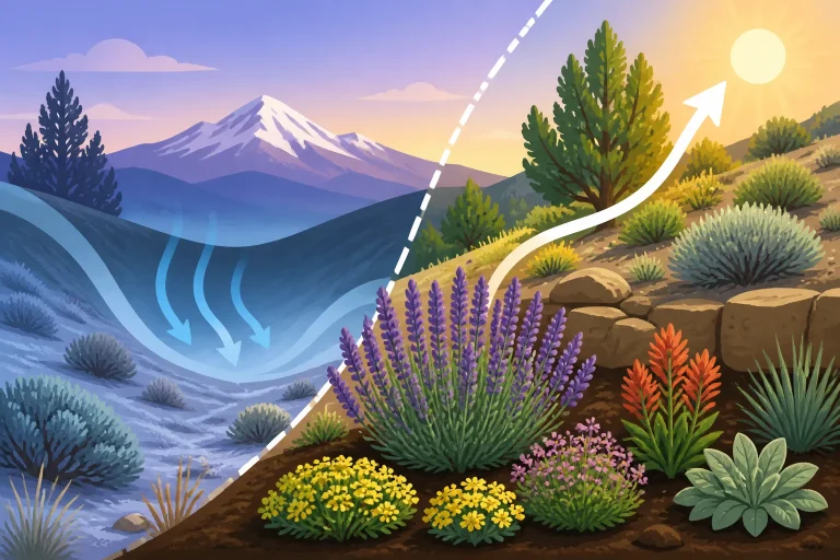
On clear, calm conditions, cold air can drain toward lower ground and collect in hollows or valley bottoms. A garden at the bottom of a slope may therefore face more freeze exposure than a nearby site higher on the slope, even when both are close to the same station. The exact pattern depends on the landscape and weather.
This is one reason that “my yard is lower” does not always mean “my yard is warmer.” A lower site can have a longer growing season in one regional context but still be a cold pocket within a local landscape. A slope can drain cold air away, while a sheltered basin can hold it.
Take note of places where frost lingers after it has disappeared from other parts of the yard. Watch whether low areas, lawn depressions, or the base of a slope stay colder than raised or more open beds. These repeated observations are often more useful for a particular garden than trying to infer an exact adjustment from a map.
Slope direction and exposure change warming
A slope’s orientation affects how much sun it receives and when it receives it. A sunny, open slope may warm more quickly than a shaded one, while a site exposed to cold wind may lose heat quickly. Buildings, fences, and tree cover further alter exposure.
These conditions matter for both air and soil. A garden can escape some cold air yet still have cool soil because it is shaded. Another site may warm quickly during the day but cool rapidly overnight. The station’s freeze record captures the temperature pattern at its location, not the combined effect of the features around your beds.
When comparing a station to a garden, write down the features that seem most relevant: elevation, whether the ground is flat or sloped, whether the site is exposed or sheltered, and where cold air might collect. The goal is not a technical survey. It is to avoid treating a station’s conditions as identical to your own.
How to choose the most useful NOAA station
Choosing a station is a practical matching exercise. Start with the stations that make geographic sense, then narrow the options by comparing landscape and exposure. A station farther away may sometimes be a better match than the closest one if it shares your elevation and terrain more closely.
Start with the broader climate region
First, identify the part of Oregon your garden belongs to in practical terms. Coastal conditions, the Willamette Valley, mountain landscapes, and the high desert do not follow a single planting rhythm. A station in the same broad region is generally a better starting point than one across a major change in terrain or climate.
That does not mean a regional label settles the choice. Conditions vary within each region. Use the regional match to narrow your search, not to assume the station gives an exact planting date for your property.
If you are comparing several possible stations, ask whether each is on the same side of major terrain features and whether it represents a similar seasonal pattern. A nearby station across a ridge may be less helpful than one a little farther away in a similar valley or basin.
Compare elevation and landform
Next, compare whether the station sits at a similar elevation and in a similar setting. A valley-floor station, a hillside site, and an exposed high-desert location can each tell a different story. Look at the land between the station and your garden as well as the locations themselves.
A station in a broad valley may still be useful for a garden in that valley, but local low spots can be colder than the station. A station on open ground may provide a useful reference for a wind-exposed garden but may not capture the protection of a courtyard. No single characteristic determines the match; several clues should point in the same direction.
Check the station’s surroundings
When station descriptions or maps are available, check what is around the site. Is it open, built-up, near a river, or surrounded by trees? A station’s surroundings can help explain why its records might differ from your yard.
Do not assume the closest station is the best one just because it is near your mailing address. Proximity matters, but similarity matters too. If two stations appear relevant, compare both rather than picking one based on distance alone.
For a detailed station-selection approach focused on freeze dates, see How to Pick the Right Oregon Weather Station for Reliable Frost Dates. The useful outcome is not necessarily choosing a single perfect station. It may be recognizing that one station describes the broad regional pattern while another helps you understand a nearby but distinct landscape.
Keep a record of the choice
Write down which station you are using and why. Note the region, elevation relationship, terrain, and exposure differences. This makes it easier to interpret the station’s information consistently rather than switching stations whenever one produces a date that seems more convenient.
If you use a planting calendar, record your own observations alongside it: when a bed’s soil becomes workable, which locations warm first, and where frost damage tends to show up. Over time, those notes help you decide whether your chosen station is a good regional reference or whether another station better reflects your conditions.
A station choice does not need to be permanent. If you move, change garden beds, or discover that your yard behaves differently from the station you selected, reassess. The objective is a useful comparison, not loyalty to a particular station.
How to interpret a last spring freeze date
A last spring freeze date describes a historical or statistical pattern, not a guaranteed end to cold weather. Even a station that usually reaches its last spring freeze relatively early can experience a later freeze in another year. Likewise, a date from a station does not say that every nearby garden will freeze on the same day—or that no garden will freeze after it.
A normal is not a forecast
Climate normals summarize typical conditions over a set period. They help place a current season in context, but they do not predict the exact sequence of weather in the coming weeks. A normal date is not an instruction to plant on that date.
A probability-based date also needs to be read as a statement about likelihood, not certainty. It does not promise that the freeze will happen or that it will not happen outside the expected window. Gardeners should keep a margin of caution for tender crops rather than treating a normal as a hard boundary.
That distinction is important when making planting decisions. A cool-season crop may tolerate conditions that would harm a tender warm-season crop. Even for a crop that can withstand a light chill, cold soil or persistent cool nights may slow growth. The station’s last spring freeze information addresses a temperature threshold at the station; it does not account for every factor that affects crop establishment.
Freeze, frost, and crop injury are related but different
A freeze is based on air temperature reaching a stated threshold. Frost refers to ice crystals forming on surfaces, and it can occur under conditions that do not match the temperature recorded at a standard station. The temperature at leaf height or near the soil can differ from a station’s measurement.
Plants also differ in their response to cold. A freeze may damage a tender crop while leaving a hardy crop largely unaffected. Young transplants can be more vulnerable than established plants, and wet or windy conditions may add stress. A freeze date cannot tell you how a particular crop will respond.
This is why station data should be one part of planting judgment. Combine it with the crop’s cold tolerance, the soil’s condition, current forecasts, and the experience of your own yard. For more on the limits of a date alone, read Why Frost Dates Alone Cannot Dictate When to Plant Oregon Vegetables.
Use the date to plan a window, not a deadline
A practical planting window gives you room to respond to conditions. Use station information to anticipate the general season, then wait for the garden itself to be ready. If the forecast signals renewed cold, delay a tender transplant or prepare suitable protection rather than sticking to a calendar date.
Planting in a window also helps avoid a common mistake: moving every crop outdoors as soon as a calendar suggests spring has arrived. Cool-season vegetables and heat-loving crops have different needs. A bed that can support hardy greens may not yet be warm enough for a crop that depends on warm soil and mild nights.
For a broader look at how to build a regionally appropriate schedule, see Adjusting Planting Calendars Across Oregon’s Climate Regions. Use that schedule as a framework, not a substitute for current conditions.
Turning station information into a garden decision
The aim of comparing stations is not to calculate an exact personal freeze date. It is to make a better-informed decision about when to prepare beds, sow, transplant, and protect crops. That requires combining regional data with local observation.
Build a simple comparison
For each station that might be useful, note the broad region, terrain, elevation relationship, and exposure. Then compare those details with your garden. You can use a table like this to organize the decision:
| What to compare | A closer match looks like | If it differs from your garden |
|---|---|---|
| Broad region | The station shares the same general climate setting | Treat its dates as regional context |
| Elevation | The station is in a broadly similar elevation range | Be cautious about applying its date directly |
| Terrain | Both sites are in a similar valley, slope, basin, or open area | Consider whether cold air may collect differently |
| Exposure | Both sites are similarly open or sheltered | Expect local conditions to diverge |
| Garden position | The station and beds have similar sun and wind exposure | Track the garden’s own warming and freeze patterns |
| Freeze history | The station’s record helps describe the regional pattern | Use it to plan, not to promise a frost-free date |
The table is a way to structure judgment, not a formula. A station can be useful even if it does not match perfectly, as long as you understand what it represents and where its limits are.
Add real-time weather and soil conditions
Historical information sets expectations; current weather helps guide immediate choices. Before moving tender starts outdoors, check the forecast for conditions near your garden and look at the likely overnight lows. A regional forecast may still miss a cold pocket, so use your own observations if your site repeatedly differs from surrounding areas.
Soil readiness matters too. After wet weather, soil may be too saturated to work without damaging its structure. Cold soil can delay germination and root growth even if the risk of a hard freeze has eased. In raised beds, a sunny location may warm earlier than heavy, shaded ground, but the result depends on the bed, its soil, and the weather.
For help deciding when the ground is ready, consult When to Plant in Oregon: Using Soil Temperature and Season Clues. That perspective complements station data: temperature and season patterns tell part of the story, while the condition of the soil and the crop determine what is sensible in the bed.
Separate crop groups
Do not treat a garden as if every plant needs the same go-ahead. Hardy greens, peas, and other cool-season crops can tolerate conditions that may set back tomatoes, peppers, squash, and other tender crops. The appropriate planting decision depends on what you are planting and whether you are sowing seed or moving a start.
Direct-sown seeds may need suitable soil conditions to germinate. Transplants may establish more readily when the soil is workable and the forecast is favorable, but they can still be stressed by cold nights. The station’s freeze date alone does not tell you whether those conditions are right.
Use crop-specific planting information rather than applying a single date to the whole garden. Starting Seeds Indoors vs Direct Sowing in Oregon Gardens can help with the choice between sowing outdoors and transplanting starts. If you are deciding about a particular crop, use a planting guide for that crop as well as the broader regional calendar.
Use protection as a backup, not a guarantee
Row covers, cloches, cold frames, and other protections can reduce exposure in some situations, but their effectiveness depends on setup and conditions. Protection does not make a garden identical to a warmer station, and it should not be treated as a reason to ignore the forecast.
A cover may be useful when a cold night threatens plants that are already in the ground. But it has to be in place appropriately, and it may not protect plants equally from cold air, wind, or prolonged chill. Consider whether the crop can simply wait until conditions are more favorable. For practical options, see Covering Garden Beds for First Frost Without Crushing Crops.
For repeated cold pockets, location can be as important as protection. Moving a container to a sheltered area or choosing a warmer bed may be more reliable than trying to compensate for a poor site every season. A station comparison can help identify where your garden is likely to face more risk, but your own observations confirm how that risk plays out.
Common mistakes when matching a station to a garden
Choosing by distance alone
The nearest station is a sensible place to begin, but it may not be the best match. A nearby station can sit in a different terrain feature or have much greater exposure. Compare the setting before relying on its date.
Treating a city’s climate as uniform
A city can include sheltered neighborhoods, open fields, slopes, and low areas. The station does not represent every part of that city. Local differences remain relevant even when the station name seems like a close geographic match.
Applying a date to every crop
A last spring freeze date does not identify the right planting date for all vegetables. Crops vary in cold tolerance, and soil warmth affects sowing and establishment. Separate the needs of hardy crops from those of tender crops.
Assuming a normal eliminates risk
A normal describes a pattern, not a guarantee. Cold weather can arrive outside the typical window. Keep checking conditions as planting time approaches, especially for vulnerable plants.
Treating elevation as a simple adjustment
There is no reliable shortcut that turns a station’s date into an exact garden date based only on the difference in elevation. Terrain and exposure matter as well. Use elevation to question the match, then combine it with local observation rather than trying to calculate a precise correction.
Ignoring what the yard shows
If frost repeatedly settles in a low corner or one bed stays cold and wet, that evidence matters. A station provides context, but it cannot overrule a pattern you can observe directly. Keeping notes on where and when cold affects the garden helps refine your planting choices over time.
Frequently Asked Questions
Should I use the closest NOAA station to my garden?
Use the nearest station as a starting point, then compare its elevation, terrain, and exposure with your garden. A farther station may be more representative if it shares a more similar landscape and regional pattern.
Does a normal last spring freeze mean frost is over?
No. A normal is a summary of typical conditions, not a guarantee for the coming season. Local gardens can also differ from the station, so continue to consider forecasts and site-specific freeze risk.
Can I adjust a station’s freeze date based on elevation?
There is no dependable single adjustment that turns a station date into an exact date for a garden. Elevation matters, but slope, cold-air drainage, wind, shade, and shelter also shape conditions.
Why can my yard freeze when a nearby station does not?
The station measures conditions at its own location. Your garden may sit in a low pocket, be more exposed, or have different shelter and ground conditions. Small landscape differences can change local freeze exposure.
What should I use with NOAA station data when deciding to plant?
Combine the station’s long-term pattern with current forecasts, crop cold tolerance, soil temperature and moisture, and your garden’s own history. Use a planting calendar to plan a window, then adapt to conditions.
Sources
- NOAA National Centers for Environmental Information — NOAA NCEI 1991–2020 Climate Normals — Portland International Airport, Oregon (checked November 14, 2026)
- NOAA National Centers for Environmental Information — NOAA NCEI 1991–2020 Climate Normals — Redmond Roberts Field, Oregon (checked November 14, 2026)
Disclaimer
This article is for general informational purposes only and does not constitute professional advice. Laws, prices and regulations vary by location and change over time. Consult a qualified professional for guidance on your specific situation. Oregon Gardening Guide is not a government agency and is not affiliated with any university extension, state department of agriculture or other government agency.